Skip to main content.
My Weather Data
Day time 28.8°C
my location
Updated: 6/21/2026 4:35 PM
Temperature
Now:28.8°C (83.8°F)
+1.1 /hr
Cond.:Day time,
High:
28.8°C @ 4:34 PM
Low:
14.3°C @ 4:37 AM
Feels like:
0.0 °C
Humidity
Current: 54 %
High:
91% @ 4:42 AM
Low:
54% @ 3:58 PM
Dew point:
18.6°C
Pressure
Current: 1025.8 mb
-0.2mb/hr
High:
1026.3 mb @ 12:11 PM
Low:
1023.5 mb @ 12:35 AM
Wind
Current: 2.3 mph NE
Gust: 1.9 mph NE
Max: 8.2 mph W
(Max: 13.3 kmh)
Rain:
Today: 0.0 mm @ -
Yest: 0.6 mm
Month: 61.0 mm
Year: 386.0 mm
Sun
Rise: 4:46 am
Set: 9:30 pm
Moon
Rise: 12:47 pm
Set: 12:45 am
Links
Weather Display Web site
Other data
Max gust last 7 days: 15.0 kts, on Mon
Max temp last 7 days: 28.7 °C, on Sun
Min temp last 7 days: 11.8 °C, on Mon
Diff in av temp last 24 hrs: -2.4 °C
Wettest curr month on record: 32.8mm 2025
Driest curr month on record: 18.6mm 2024
Validation
This page is XHTML 1.0 compliant. Validate the
XHTML
and
CSS
of this page.
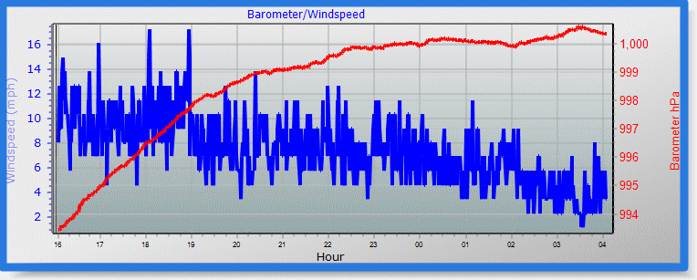
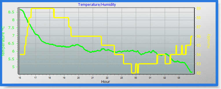
Last 24 Hours
Auto Scale graphs